Specification content:
3.1.1.2 Drainage basins as open systems.
Inputs and outputs to include precipitation, evapotranspiration and runoff; stores and flows, to include interception, surface, soil water, groundwater and channel storage; stemflow, infiltration, overland flow, channel flow.
3.1.1.2 Drainage basins as open systems.
Inputs and outputs to include precipitation, evapotranspiration and runoff; stores and flows, to include interception, surface, soil water, groundwater and channel storage; stemflow, infiltration, overland flow, channel flow.
1. What is a drainage basin?
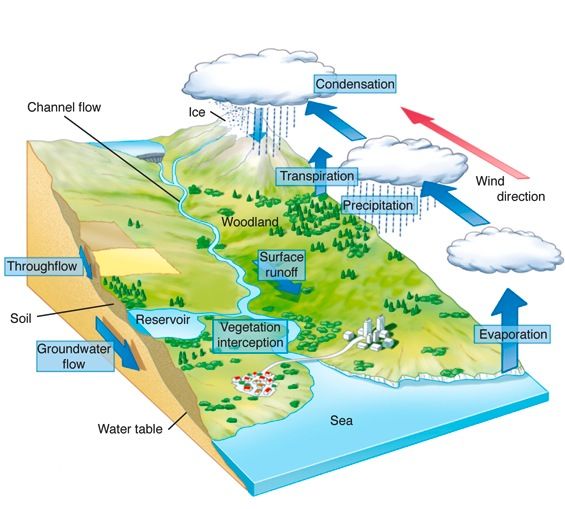
Drainage basins are local open systems. A drainage basin is an area of land drained by a river and its tributaries (river system). It includes water found in the water table and surface run-off. There is an imaginary line separating drainage basins called a watershed. Usually, this is a ridge of high land.
At a hillslope local level, water will move through a specific area until it meets a larger body of water. Water will flow over a hillslope until it reaches a tributary, the tributary will gradually join a larger river, the river will flow into the sea. This is another example of a cascading system and demonstrates the spatial scales changes within the hydrological system.
At a hillslope local level, water will move through a specific area until it meets a larger body of water. Water will flow over a hillslope until it reaches a tributary, the tributary will gradually join a larger river, the river will flow into the sea. This is another example of a cascading system and demonstrates the spatial scales changes within the hydrological system.
2. Runoff variation.
The amount of runoff a drainage basin will see can be very challenging to predict, but runoff variations are fundamental to the study of the drainage basin. Several factors will affect the system within a drainage basin:
- Changes that occur over time such as the amount of rainfall, evapotranspiration and the amount of discharge in a river or stream.
- Spatial variations can have an impact as within one drainage basin as there will be changes in the gradients of slopes, the amount of soil will vary depending on upland/lowland conditions, the moisture content and the variance in tributaries and relief of each one.
- Another issue is that for much of the flow of water within a drainage basin it occurs underground which has a significant impact on the ability to take valid and accurate measurements of a whole basin.
3. Processes in the drainage basin.
Key terms:
Inputs.
PRECIPITATION: Any source of moisture (liquid or solid) from the atmosphere reaching the ground e.g. rain, snow and hail.
Storage.
INTERCEPTION: Water ‘caught’ by trees and vegetation and therefore is prevented from immediately reaching the ground.
SURFACE STORAGE: Water held on the ground surface to form puddles.
GROUNDWATER STORAGE: Thus us water stored below the water table in natural underground reservoirs called AQUIFERS.
VEGETATION STORAGE: Water taken up by plants. It includes all the water held by plants in a drainage basin at any time.
CHANNEL STORAGE: This is all of the water held in the river channel.
WATER TABLE: water stored in the rock below the soil. The water table marks the top of the ZONE OF SATURATION which is the area where all of the pore spaces in the rock are full of water.
Flows.
INFILTRATION: Water that is soaking into the soil. The rate of infiltration is affected by soil type, soil structure, how much water is already in the soil, and the climate.
SOIL MOISTURE: Water held in soil layers.
PERCOLATION: Water seeping down through the soil into the water table.
GROUNDWATER FLOW: is water flowing slowly below the water table through permeable rock. Rocks that are more permeable and have more joints and bedding planes will allow a more rapid movement of water.
THROUGHFLOW: Water moving slowly downhill through the soil.
OVERLAND FLOW: (Also known as surface runoff) is the water flowing over ground. It can be in large bodies of water or small channels and rivulets. It occurs when the rain falls faster than can be infiltrated into the soil.
BASE FLOW: Groundwater flow that feeds into rivers through the drainage basin.
STEMFLOW: Water which runs down a stem to leaf or tree trunk of a plant and into the main system.
Outputs.
EVAPORATION: When liquid water turns to water vapour and is lost to the atmosphere.
TRANSPIRATION: Transpiration is the loss of water from tiny pores in the leaf surface called stomata.
EVAPOTRANSPIRATION: The combined processes of evaporation and transpiration. It is often difficult to calculate separate amount of water loss from these two processes so they are often grouped together.
RIVER DISCHARGE: The amount of water flowing past a given point in the river measured in CUMECS.
Surface Runoff.
Precipitation (INPUT).
Inputs.
PRECIPITATION: Any source of moisture (liquid or solid) from the atmosphere reaching the ground e.g. rain, snow and hail.
Storage.
INTERCEPTION: Water ‘caught’ by trees and vegetation and therefore is prevented from immediately reaching the ground.
SURFACE STORAGE: Water held on the ground surface to form puddles.
GROUNDWATER STORAGE: Thus us water stored below the water table in natural underground reservoirs called AQUIFERS.
VEGETATION STORAGE: Water taken up by plants. It includes all the water held by plants in a drainage basin at any time.
CHANNEL STORAGE: This is all of the water held in the river channel.
WATER TABLE: water stored in the rock below the soil. The water table marks the top of the ZONE OF SATURATION which is the area where all of the pore spaces in the rock are full of water.
Flows.
INFILTRATION: Water that is soaking into the soil. The rate of infiltration is affected by soil type, soil structure, how much water is already in the soil, and the climate.
SOIL MOISTURE: Water held in soil layers.
PERCOLATION: Water seeping down through the soil into the water table.
GROUNDWATER FLOW: is water flowing slowly below the water table through permeable rock. Rocks that are more permeable and have more joints and bedding planes will allow a more rapid movement of water.
THROUGHFLOW: Water moving slowly downhill through the soil.
OVERLAND FLOW: (Also known as surface runoff) is the water flowing over ground. It can be in large bodies of water or small channels and rivulets. It occurs when the rain falls faster than can be infiltrated into the soil.
BASE FLOW: Groundwater flow that feeds into rivers through the drainage basin.
STEMFLOW: Water which runs down a stem to leaf or tree trunk of a plant and into the main system.
Outputs.
EVAPORATION: When liquid water turns to water vapour and is lost to the atmosphere.
TRANSPIRATION: Transpiration is the loss of water from tiny pores in the leaf surface called stomata.
EVAPOTRANSPIRATION: The combined processes of evaporation and transpiration. It is often difficult to calculate separate amount of water loss from these two processes so they are often grouped together.
RIVER DISCHARGE: The amount of water flowing past a given point in the river measured in CUMECS.
Surface Runoff.
- Precipitation deposits rainfall on the ground surface. The conditions of the ground will depend on how much water is on the surface.
- Depressions of the surface will fill with water, and overflow. It catchments where there are slopes of a greater angle, surface runoff is more likely.
- It is only likely to occur in certain conditions, and at certain times of the year.
- Small channels are likely to be created in order to transport this water, but will cease to flow once the amount of water entering the system decreases.
- Surface runoff may increase in areas that have been deforested or urbanised.
Precipitation (INPUT).
- Any source of moisture (liquid or solid) from the atmosphere reaching the ground e.g. rain, snow and hail.
- The intensity of the rainfall (which is measured in mm/hour), is known as the Precipitation intensity. During intense rainstorms, precipitation intensity may exceed infiltration capacity within the soil. This often will lead to increased levels of overland flow. This is known as Hortonian Overland Flow.
- Horton's theory said that in intense storms there was infiltration-excess overland flow and this is important on a hillslope because the rising limb of a storm is made up of water that is unable to soak into the soil because the intensity of precipitation has exceeded infiltration capacity. This relates directly to storm runoff which is very important in measuring the hillslope via a storm hydrograph.
- This is the process by which water soaks into the upper soils.
- The infiltration capacity is the maximum rate at which the soil surface can absorb falling rain (or glacial meltwater from the cryosphere).
- The rate of infiltration is affected by cryospheric processes, vegetation cover, soil compaction and the size of soil pores.
- Some of the infiltrated water will percolate through the soil to deeper layers and the rest will flow downslope by throughflow.
- Soil pipes are common within the soil structure. They act as preferential paths for the water to move through the soil.
- The gradient of the hillslope will affect the amount and speed of movement of the throughflow.
- If the water table is higher than parts of the ground on the hill, then water will flow out of the ground into flatter depressions as return flow. This is called exfiltration.
